Mineral exploration,
without the GIS
overhead.
GeoMiner turns Earth observation data into mineral prospectivity targets and alteration maps you can actually use. Define a concession, select your deposit model, generate ranked targets. No complex setup, no GIS software.
Define study area
Draw or upload your boundary. Delineate regional exploration blocks up to 2,500 km².
Choose deposit model
Select Porphyry Cu-Au, Epithermal Au, Lithium (LCT), Iron Gossan, or VMS Base Metals presets.
Run targeting
Our spectral and structural models process your data on Google Earth Engine in seconds. No coding.
Get ranked targets
View your prospectivity map, inspect ranked polygons (Tier 1–3), and export to Leapfrog Geo.
From regional screening to drill targets
Whether screening Andean copper belts, Western Australian lithium pegmatites, or VMS shear corridors, GeoMiner delivers verifiable remote-sensing proof.
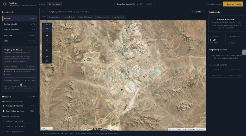
Unified Remote Sensing Command Center
Interactive multi-temporal AOI delineation over Escondida Cu-Au with 12 layered spectral products, deposit-model AHP consensus, and instant target footprint telemetry.
Hydroxyl (Al-OH) & Gossan Diagnostics
Diagnostic SWIR1/SWIR2 (B11/B12) and Red/Green (B4/B3) ratios mapping phyllic sericite halos, advanced argillic alteration, and supergene iron oxide gossans.
Multidirectional Hillshade & Lineaments
Blends 0°, 45°, 90°, and 135° illumination azimuths with Sobel spatial filters to reveal shear fault corridors, structural dilatation zones, and fracture intersections.
Multi-Criteria Target Ranking Engine
Analytic Hierarchy Process (AHP) synthesizing alteration, structure, gossan, and terrain into auditable 0–100 ranking scores with automated bare-rock NDVI screening.
Authentic exploration layers ready on click
Explore the exact earth observation layers computed on Google Earth Engine supercomputing clusters inside GeoMiner.


Inspect pixels, curves, and time series
GeoMiner is engineered for exploration geologists who need to verify ground truth with physics-based diagnostics before publishing conclusions or planning drilling.
Full Spectral Signature Graph
Click any pixel on Earth to graph its exact 10-band surface reflectance profile from coastal blue to SWIR-2. Differentiate phyllic sericite from unaltered host rock.
Pixel Trajectory & LandTrendr
Segment multi-year Sentinel-2 medians from 2018 to 2025 to separate permanent open-pit mine excavations from seasonal vegetation phenology.
Split-Screen Comparison Curtain
Drag an interactive vertical curtain to immediately detect spatial relationships between optical satellite feeds and hydrothermal alteration masks.
Every result exports in publication formats
Take classified alteration layers and ranked vector targets directly into QGIS, ArcGIS, Google Earth, or Leapfrog Geo.
Start your first targeting survey.
Launch the workspace, pick any concession on Earth, and receive instant mineral prospectivity intelligence and ranked exploration targets.